 | |||
| http://upload.wikimedia.org/wikipedia/commons/thumb/1/1c/Tang_Dynasty_circa_700_CE.png/250px-Tang_Dynasty_circa_700_CE.png |
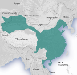
Tang Dynasty: 618-907 AD
The Tang Dynasty took control of almost all of China and Vietnam, impacting as far as Japan, Korea, and Central Asian countries, such as Afghanistan. The boundaries lay from the Tarim Basin in the west, to the Korean Peninsula in the east, Mongolia in the north, down to modern Vietnam. The boundaries consist of a broad area that ascended from east to west. The lowlands lay in the east, consisting of the Manchurian Plain and the North China Plain. Rivers flowed west to east, emptying out into the Pacific Ocean. Several important rivers were the Xi, Yangtze, Yellow, and the Wei Rivers. Plateaus and mountains make up the west side of the Yang Dynasty. Deserts were also located to the north and west of the dynasty. The people of the Tang Dynasty made excellent use of the rivers, reopening the Silk Road to the world. Chinese traders began using the sea as another way to transport goods, which was called the Maritime Silk Road. During this prosperous period of trade, many foreign traders and merchants came to live in southern Chinese cities. Most cities were located in the lowlands where farming was best, creating abundances of food to support a growing population. The deserts and mountains that surrounded the western side of the Tang Dynasty kept out invaders and protected the dynasty for many years.
Information:
http://totallyhistory.com/tang-dynasty-geography
http://lilianaintegratedproject09.wikispaces.com/The+Tang+Dynasty%27s+Climate+and+Geographic+Factors
http://www.newworldencyclopedia.org/entry/Tang_Dynasty
Information:
http://totallyhistory.com/tang-dynasty-geography
http://lilianaintegratedproject09.wikispaces.com/The+Tang+Dynasty%27s+Climate+and+Geographic+Factors
http://www.newworldencyclopedia.org/entry/Tang_Dynasty
No comments:
Post a Comment